")
")
")
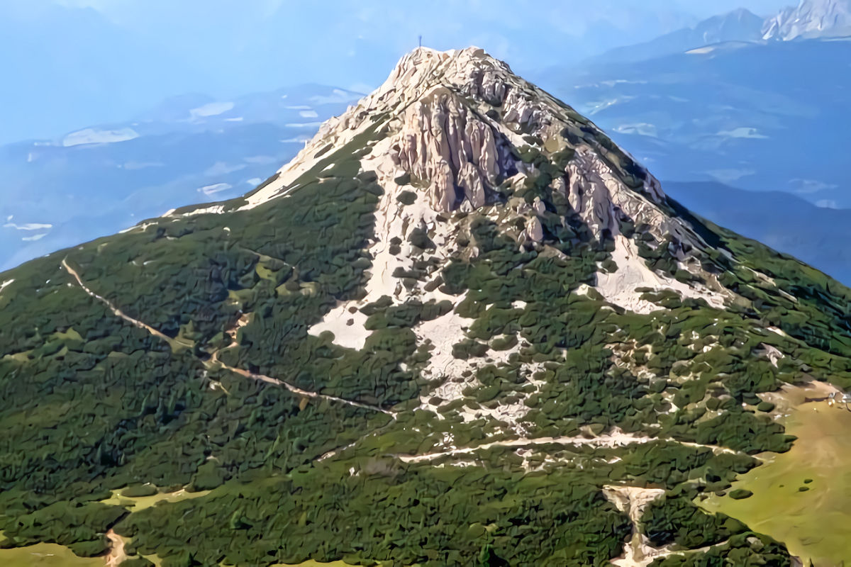
Starting from the Mas dei masi, cross the town of Cavalese and continue in the direction of the town of Daiano, and Varena following the signs to arrive at Passo di Lavazè 1805 meters above sea level. Arrived at Passo di Lavazè, continue towards Passo dei Oclini 1989 meters above sea level. Once at the pass, you can easily park your car in the car parks of the ski lifts. From the car park, continue on the dirt road towards Malga Gardin, the path that leads to Corno Bianco begins just below the Oclini pass refuge, it takes about 1 hour. Initially you go up a slope on a meadow, to then continue a stretch among the pines, there are various detours the main path is well marked.Shortly after halfway along the path, continue on a rocky ground passing through some mountain pines. When you reach the end of the pines from the main path you see a secondary path that leads towards the crest of the Corno Bianco. You go up passing some easy rocks. (the one made by me) From the beginning of the ridge to get to the summit cross it takes about 10 minutes enjoying a beautiful panorama.
Return: To return, you can retrace the outward path or take one of the many paths that start towards Malga Gardin. The return made by me is the path that leads to the Canyon Bletterbach and Malga Gardin. Descend from Corno Bianco on path number 5 and pass between rocks, there is also a safety cord, at the end of the downhill section continue along a ridge until you reach a junction with path 5 towards Pietralba and path H which leads back to the Passo dei Oclini. On the left (there was no trail sign) you can see a clearly visible path on a rocky bottom that descends along the Bletterbach Canyon. You arrive at the stream (which I found frozen), cross it and continue uphill until you cross path W. Here you continue for a short stretch among mountain pines and then continue along a wooded path. You reach a second crossroads with the W path and the W-H path which leads towards Passo Oclini and the panoramic route, I continued on the W path Redagno - visitor center, another third crossroads and continue on the W path, you reach the end of the wood and continue on the forest road after about 200 meters you will find the trail signs for Malga Gardin path 12A continue to the left along a wooded path, from here it takes about 20 minutes to get to the malga. Once you reach the malga, continue on the dirt road and it takes about 30 minutes to get to Passo dei Oclini. Difficulty: E Excursion Time required: 5 hours


